Recently Viewed ›
Recently Downloaded 
Close x
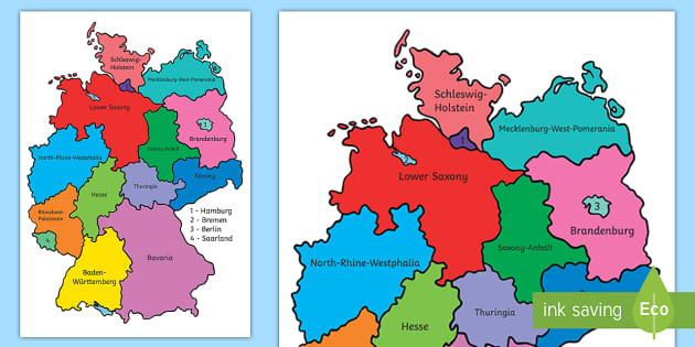
Are you teaching your class about Germany? This bright and colourful Germany map is a must-have resource for your lessons.
 germany
map of germany
german map
deutschland
bundesländer
map of france
deutsch
uk map
german worksheets
all about germany
german display
germany activities
germany map blank
germany
map of germany
german map
deutschland
bundesländer
map of france
deutsch
uk map
german worksheets
all about germany
german display
germany activities
germany map blank
Are you teaching your class about Germany? This bright and colourful Germany map is a must-have resource for your lessons.
Once you've downloaded this resource, you'll have access to a wonderful map of the German Federal States. Each state is clearly identified through different colours, with an accompanying label for their titles.
Using this resource, children will be able to learn the names for each state in Germany, and where they're located. Whether you use this resource as an introduction to Germany, or as a useful poster in your classroom, this is a useful resource to keep handy.
This Germany Map is compatible to be printed in both A3 or A4 sizing. Perfect to cater for your different lesson ideas. Simply download to get started!
If you found our Germany Map useful in your lesson, then why don't you take a look at more of our wonderful resources designed to aid and enhance learning on this topic?
Explore some of our wonderful recommendations below:
All of our resources are designed by our specialist team and approved by experienced teachers to ensure that you're being provided with the highest quality of content. Perfect for helping you to easily plan and prepare your lessons in advance.
 Home
Home  Membership
  TwinklCares
  Create
  Blog
Blog